3 canine teams from L.A. County Fire Department leave for Maui to assist with search and rescue efforts.
The massive wildfire in Maui has triggered an outpouring of help from across the nation, and a coalition from Los Angeles County Fire Department left for the island to assist with search and rescue efforts.
Three LAFD canine teams departed from LAX late Sunday morning to provide aid and support to the Maui Emergency Management Team.
“We’re expecting about a two week deployment,” said L.A. County Fire Department firefighter paramedic Nicholas Bartel. “We are going to go find the victims of the fire and bring closure to the families.”

Bartel is joined by Captain Celina Serrano and firefighter paramedic Edward Ruiz, as well as K9 Prentiss, K9 Harper and K9 Six.
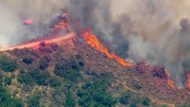
Search and recovery efforts on the state’s second-largest island are ongoing and will continue for the foreseeable future. The death toll from the wildfire has risen to 93 as of Sunday afternoon, officials said.
The Maui wildfire is the deadliest in the United States in over a century, and according to Hawaii Gov. Josh Green, it will ‘certainly’ be the worst natural disaster in the state’s history.
“It’s going to be, in the short term, heartbreaking, in the long term, people are going to need mental healthcare services, and in the very long term, we will rebuild together,” Gov. Green said at a press conference.
Gov. Green says that the fire has caused nearly $6 billion in damage, and that figure is likely to rise.
At least 2,200 buildings in West Maui were destroyed, including nearly the entire village of Lahaina. According to officials, as many as 4,500 people are in need of shelter.
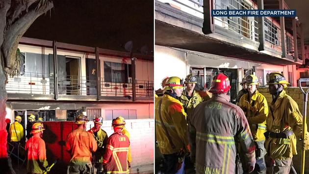
2 women killed, 3 more people hurt in Long Beach pleasure boat fire

Firefighters fought the fire on land and in the water. Heflin said no firefighters were injured.
Jed Gibbs, 20, a host at The Crab Pot restaurant and bar, said he was looking out the doors that give diners a view of the marina when he heard a pop, a commotion and saw a small plume of black smoke about a quarter-mile away that quickly grew.
Gibbs said he did not hear any screams, and the smoke prevented him from seeing what others were doing in an attempt to rescue the victims and put out the flames.
“It was a little bit crazy. We really don’t have much of these,” Gibbs said, recalling a boat fire in May at a rental shop. “Everybody stopped what they were doing and looked at what was going on. It was a little surreal.”
Restaurants, boat-rental shops and the Wibit aquatic playground typically bring out a large crowd to the area on Saturdays during the summer, Gibbs said.
“People looking to have fun, a lot of those sorts of people,” he said.
The wreckage of the boat was towed to an isolation dock to prevent environmental impacts such as leaking fuel, Heflin said.
The investigation into the fire will include reports that the boat was either fueling or had just finished fueling when it burst into flames, Heflin said.
Staff writer Brian Rokos and City News Service contributed to this story.

Drones Take Flight for Local Government
Four regions of the country are poised to take advantage of relaxed rules from the FAA.
Two people were killed and three more were hospitalized with burn injuries Saturday, Aug. 5, in a fire involving a 35-foot pleasure boat in Long Beach’s Alamitos Bay. (Photo courtesy Long Beach Fire Department)

Two women were dead and two men and a woman were hospitalized with burns after a fire Saturday involving a 35-foot pleasure boat in Long Beach’s Alamitos Bay, the Long Beach Fire Department said.
All of those killed and injured were in their 60s, Long Beach Fire Capt. and spokesman Jake Heflin said.
Fire and police officials were called to Alamitos Bay in Long Beach on Saturday after a boat fire left two people dead and three more injured. (Photo by OC Hawk)

Smoke is visible from a boat fire in Alamitos Bay on Saturday. (Photo courtesy Long Beach Fire Department)
It happened in the 200 block of Marina Dive near a fuel dock near Long Beach Fire Station 21, the fire agency said on social media. Alamitos Bay is near the Orange County line and the Orange County Fire Authority assisted with the fire fight.
The identities of those involved were not immediately released and the cause of the fire was under investigation. The fire was reported at 5:17 p.m.
Firefighters rushed to the scene of the large, smoky fire that could be smelled by residents throughout the east side of Long Beach and seen throughout the marina area. Video from the scene showed the boat was adjacent to a dock as crews sprayed water on the fire. Heavy fire was burning in the rear of the boat with thick black smoke billowing into the air.
/ July/August 2018

Shutterstock
Once a bulky, powerful tool mostly used in the armed forces, drones have finally reached the hands of average people and the local governments that serve them.
And they have a lot of ideas: Use drones to gather intelligence during rapidly evolving public safety situations. Fly them above fires to get better information on how to put them out. Send defibrillators to people having heart attacks.
Drones would be doing all those things, except that the Federal Aviation Administration’s regulations make them impractical. Operators can’t fly drones above groups of people, at night or beyond their line of sight without getting waivers that can take months to receive.
So the FAA has set out to relax those restrictions. The administration is running a program, called the Unmanned Aerial System Integration Pilot Program, where local government and private partners will run tests doing exactly the kinds of things they can’t currently do. The idea is that the FAA will observe the tests and use what they learn to rewrite the rules.
The 10 test sites they selected in May — the Choctaw Nation of Oklahoma; San Diego; Herndon, Va.; Kansas; North Dakota; the Mosquito Control District in Lee County, Fla.; the Memphis-Shelby County Airport Authority; North Carolina; Reno, Nev.; and the University of Alaska Fairbanks — will become important locations in influencing the future of drone use in the U.S., especially as it concerns state and local government.
But in running the contest, the FAA gathered ideas from a lot more places than it chose. In all, 150 different communities applied. The list of people who signed up as interested parties is even longer — more than 2,500 people from all across the country, and some from other countries, contacted the administration.
In reviewing that list, Government Technology found that there are some places in the U.S. that look like particular hot spots for public-interest drone use. In fact, some of them were sparsely populated areas that exhibited more interest than major cities.
The four that really stood out were Huntsville, Ala.; the Washington, D.C.-Northern Virginia area; Denver; and the state of Montana.
In the end, only one of those areas — Northern Virginia — featured a winning applicant. But the four areas, being diverse and geographically distant from each other, hold a lot of insight into how drones might become important for government in the future as they become easier to operate in more situations.
DENVER AND COLORADO
The restriction probably holding back drones the most is the prohibition on flying beyond the operator’s line of sight.
Ben Miller, director of the Colorado Center of Excellence for Advanced Technology Aerial Firefighting (and of no relation to the author of this article), knows first-hand why that’s important. He used to fly drones for the Mesa County, Colo., Sheriff’s Office.
“I flew drones on guys with guns,” he said. “I would’ve loved to be farther away from them.”
There are a lot of reasons Denver, and Colorado in general, might be a hot spot for drones. Miller points out that there’s a history of aviation in the state — the U.S. Air Force Academy sits just outside Colorado Springs. And there’s a thriving tech industry in the Denver area.
Mark Edson, a deputy sheriff in the Arapahoe County, Colo., Sheriff’s Office, thinks the weather might have something to do with it, too.
“I would say having 300 sunny days a year is beneficial to drone flight,” he said.
Edson and Nate Fogg, the Sheriff’s Office’s emergency manager, have several ideas for how they would use drones if restrictions were relaxed.
The county they protect has some unique challenges. It’s shaped like a long rectangle, more than 70 miles from end to end stretching from the southern suburbs of Denver to the grassy fields out east. It’s a long trek from one side to the other.
They have a lot of things to monitor in that rectangle — particularly fire. All that grass is good fuel for a blaze. Then there’s the matter of regular explosions nearby.
“We have a former bombing range … for the Air Force from the end of World War II up through Vietnam,” Fogg said. “The Army Corps of Engineers is still doing all the work of the unexploded ordnance out there, and it’s not uncommon to have a fire.”
Sending a fire truck and crew out to see whether a column of smoke is a blaze or just a run-of-the-mill detonation isn’t a good use of resources. For that matter, neither is sending a truck out to a reported fire only to find out that it wasn’t needed.
Flying a drone would be better. But if an operator isn’t able to fly beyond their line of sight, they would have to travel along with the drone.
There’s also the matter of flooding. In 2013, Arapahoe was one of several counties in the area overwhelmed with water during an intense storm. In responding to those kinds of situations, emergency officials need to know where the damage is and what kind of situation they’re headed into.
“Landscape changes,” Fogg said. “We had … channels changing, roads that disappeared, that sort of thing. So we can get good images, use that for disaster planning [and] financial reimbursement through the federal government if it’s available.”
MONTANA
Montana had a particularly bad fire season last year, with blazes sweeping across more than a million acres of land.
“Last year, our fire season ran pretty late. It ran through September,” said Jennifer Fowler, director of autonomous aerial systems at the University of Montana. “So then the land managers are automatically going, ‘What do I need to do for restoration? We’re talking about logging operations, do I need to be out there planting trees and when do I do that?’”
Fire is one reason Fowler thinks her state showed so much interest in the FAA’s drone program. She also pointed out that the state doesn’t have a very dense population or a lot of airports — which means there’s a lot of more-or-less unrestricted airspace. In other words, it’s an easy environment to test in.
“Our certificates of authorization tend to be much less complicated because our air space is much easier to work in,” she said.
There are a lot of ways drones might help firefighters. Operators could use them to get a better view of where a fire has spread to, which could give them a better idea of how to fight it. As crews move into areas that have been burned, drones mounted with thermal cameras could point out hot spots on the ground.
Fire departments are already starting to do these things. But it’s fairly hard to do while complying with the rule to not operate the drone beyond visual line of sight.
“Particularly in western Montana, the pilot could be on one side of a mountain and the drone could be on the other side,” Fowler said.
Drones could also help perform work to prevent fires from getting so bad; more efficiently so if they could be flown beyond the operator’s field of vision. Land managers can use them to do studies of forests — how many trees there are in which places, what the moisture conditions are, how much fuel there is for a blaze.
And it’s not just FAA regulations preventing some of these things from happening. Fowler can tick off a host of questions she has that will affect when and where drones are actually practical for government to use — how long do the batteries last? How fast can a drone deliver its data to a user? What about in places lacking a good Internet connection?
“What’s the maximum size of a fire that a UAV can actually fly, get the information, process it and get it back to a manager so they can actually do something with the information?” she said. “And depending on how many pictures you’re taking, doing photo barometry, it could take up to 24 hours just to process the information and then you’ve missed your deadline.”
HUNTSVILLE, ALA.
Huntsville, population 180,000, is perhaps one of the most disproportionately technology-heavy cities in the U.S. It’s home to a public university, a NASA space center that was instrumental in the 1960s Space Race, and the U.S. Army Aviation and Missile Command.
And Dave Arterburn, director of the Rotorcraft Systems Engineering and Simulation Center at the University of Alabama in Huntsville, thinks it’s a great place to test drones. That’s because of the diversity of its air space — in addition to all the military aircraft around, Huntsville is an inland port with rail and truck service as well as an airport. It has an urban core, suburbs and lots of surrounding rural areas.
“We have all types of air space related to specific issuesin air operation,” he said.
Arterburn is particularly interested in package delivery, and the ability of drones to streamline the whole process.
“We’re talking about the range of delivery, all the way down from cargo to personal delivery,” he said.
But there are a lot of other ways he could see drones being helpful with relaxed restrictions. One of them is studying the weather and improving forecasting models.
With balloon launches, weather forecasters can get a lot of information. But balloons have a tendency to drift. Drones go where they’re told.
Specifically, that means scientists could use them to move up and down vertical columns of air with all the sensors they need to gather good data. To do that, they would probably need to fly up high enough that operators on the ground couldn’t see them anymore.
“If you can gather all the same [information] but for columns of air ahead of the front … those models become much more accurate,” Arterburn said.
Finally, he has an interest in studying ways to help drones navigate on their own when an operator isn’t directly controlling their movements. In particular, he said, the government can use buildings as markers to help drones orient themselves.
That could free them to draw their own routes, keeping out of restricted air space and dangerous areas while traveling to where they can do something useful for a public agency. Or, perhaps, deliver a package.
“My building at UAH isn’t going anywhere, so why not let the UAS use that as a highly accurate point of navigation that doesn’t cost the city a lot?” Arterburn said.
GREATER WASHINGTON, D.C.
Most people interviewed for this article pointed to one particular driver of drone use and development in the U.S. — the military.
So it makes sense that the nation’s capital city, home to the Department of Defense, would be a key area for drone use. John Coffey, a retired naval aviator, is well familiar with it.
“Watching over the past 10 years how the market’s transitioned from pretty much military-only use for unmanned systems into the commercial space and now the consumer space is very, very exciting,” he said.
Coffey is now executive director of unmanned systems with Cherokee Nation Technologies, which acted as a private-sector partner for multiple applications in the FAA’s drone program (it’s part of the successful Alaska proposal). He pointed to a common understanding of the three Ds of drones: dull, dirty and dangerous work.
“Going out and surveying a farm or surveying a forest, which is just a boring mission … that very same forest that you just surveyed that was healthy and doing well catches on fire, and now you’re going from a very dull mission to a very dangerous mission surveying wildfires,” he said.
Thomas Zajkowski, a program manager for Cherokee Nation Technologies and also a flight operations manager at North Carolina State University, sees sort of a backward relationship between D.C. and state and local government when it comes to drones.
That is, a lot of those governments rely on the federal government to provide drone operations when needed. If a fire or some other incident is too small to merit federal attention, they might not have access to drones.
But if the FAA lowers the bar for operation and those governments can use drones more easily, that might not matter as much.
“That gives them information they need quicker that they wouldn’t have had unless they had a bigger response,” he said. “They would have had to wait for the federal government to get there.”
The winning proposal from the area was from the Center for Innovative Technology in Herndon, Va., close to Washington Dulles International Airport. That proposal is broad, but will include urban and rural package delivery, mapping technology, radar and more.
READY FOR TAKE-OFF
There’s a whole constellation of other possible uses for drones among state and local governments. They might use drones to inspect infrastructure. They might use them to deliver supplies to disaster victims. They could send them out to spray mosquitos with pesticide. They could grab quick imagery of a crime scene. They could map nature trails or search for missing hikers.
In fact, local governments are already doing most of those things.
The key to the future, according to Miller, is expanding their ability to do those things. If government operators can use drones above people, at night and in remote places, they could do all of those better, faster and at more convenient times.
“The benefit of UAS is mobility,” he said. “You’re giving mobility to things that had limited mobility before.”
And as costs come down and operating restrictions get rolled back, Miller said he has a fourth D to add to the list.
“I might say dull, dirty, dangerous and democratized,” he said.
Long Beach Fire Department Becomes First on West Coast to Provide Recruits Mental Health Training
March 16,2018

Newly recruited Long Beach firefighter-paramedics are now being sent into the field estith a few more items in their toolbox—training on how to help people suffering from mental illness.
In late February, the Long Beach Fire Department’s HEART team led the department’s 21 newest recruits on an 8-hour course that teaches a five-step action plan encompassing the skills, resources and knowledge to help those in crisis connect with professional, peer and self-help care.
Deadly mudslides in Southern California
Updated 7:00 PM ET, Thu January 11, 2018
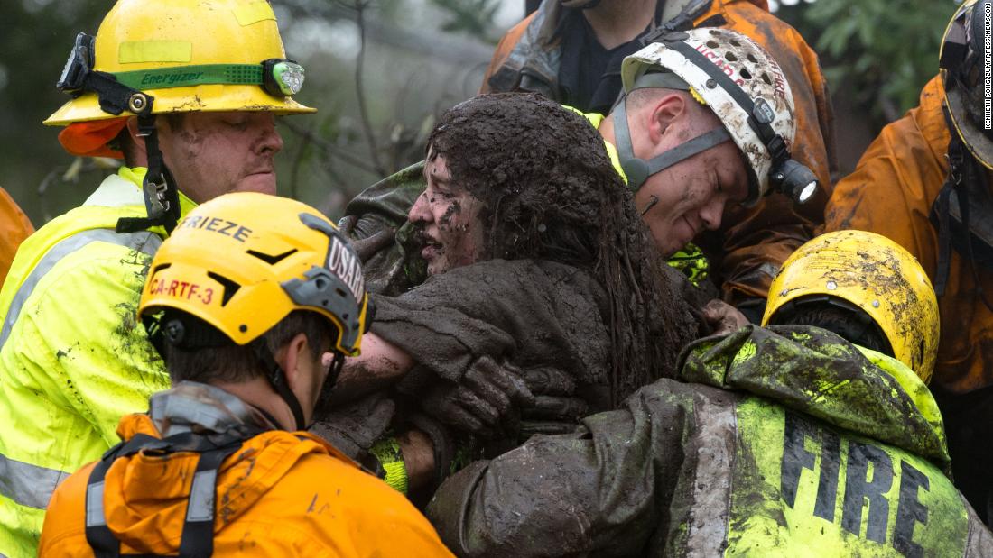
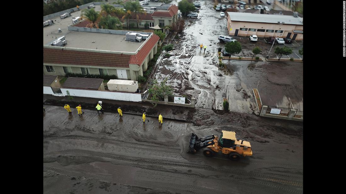
January 9, 2018 – U.S. – Monteciti, California, U.S. – A woman is rescued from a collapsed house by Long Beach Fire Department firefighters on Hot Springs Road in Montecito. Areas that had been roadways, driveways, and homes, are now unrecognizable due to the large amount of mud and debris flows. At least 17 people died and 8 are still missing, as thousands fled their homes in Southern California as a powerful rainstorm triggered flash floods and mudslides on slopes where a series of intense wildfires had burned off protective vegetation last month.(Credit Image: ?? Santa Barbara News-Press via ZUMA Wire) (Newscom TagID: zumaamericasnineteen764901.jpg) [Photo via Newscom]
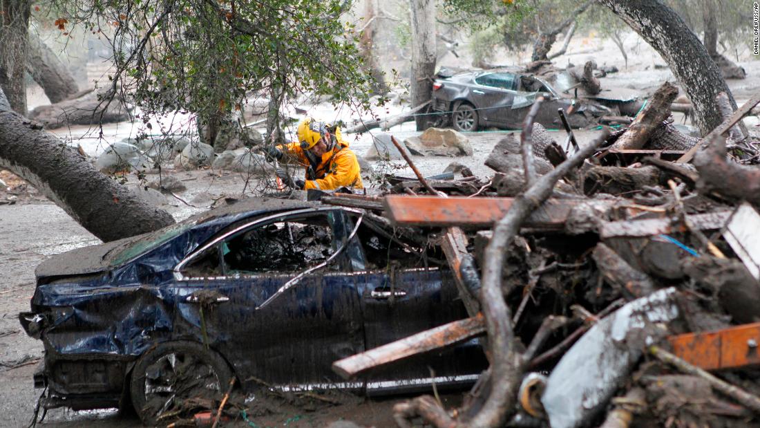
A member of the Long Beach Search and Rescue team looks for survivors in a car in Montecito, Calif. on Tuesday, Jan. 9, 2018. Several homes were swept away before dawn Tuesday when mud and debris roared into neighborhoods in Montecito from hillsides stripped of vegetation during a recent wildfire.
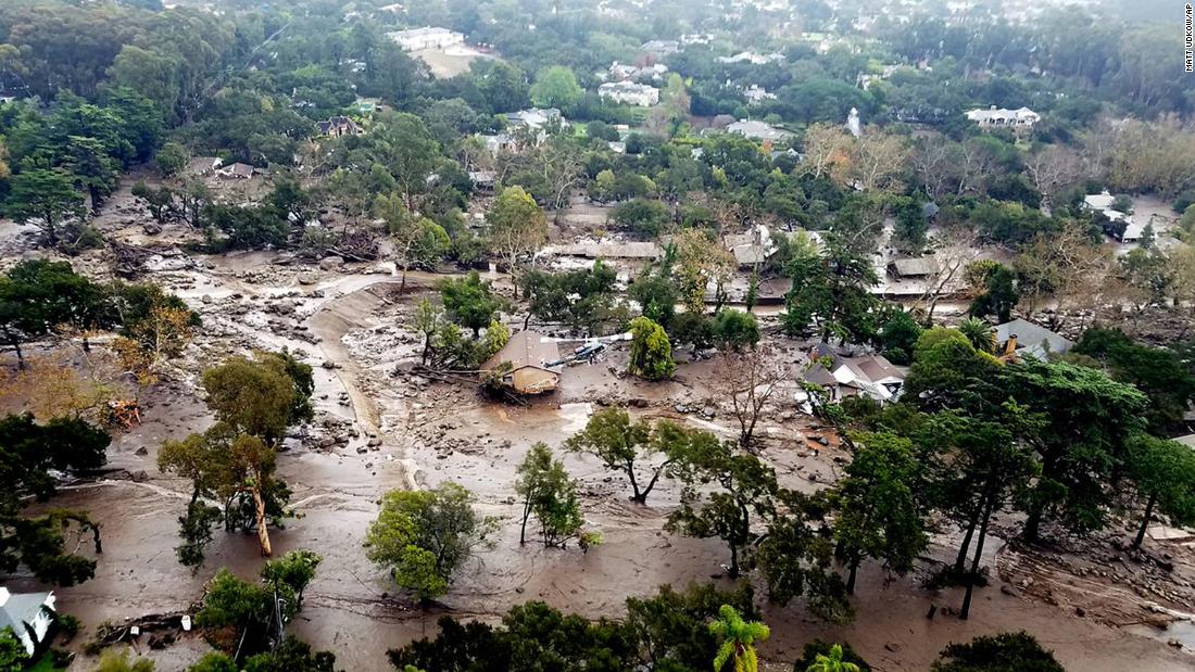
This aerial photo provided by the Santa Barbara County Fire Department shows mudflow and damage to homes in Montecito, Calif., Wednesday, Jan. 10, 2018. Anxious family members awaited word on loved ones Wednesday as
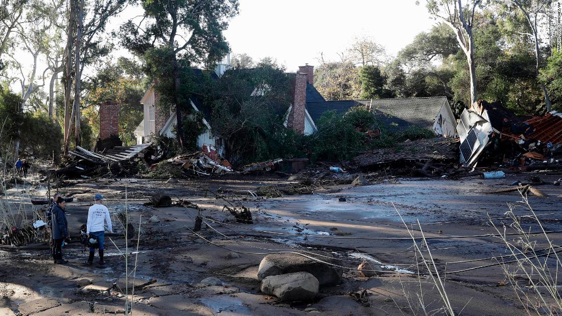
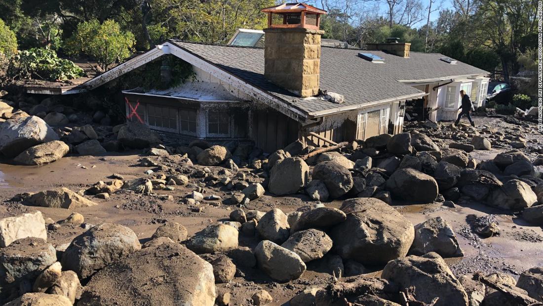
A damaged home is shown in Montecito, Calif., Wednesday, Jan. 10, 2018. Dozens of homes were swept away or heavily damaged and several people were killed Tuesday as downpours sent mud and boulders roaring down hills stripped of vegetation by a gigantic wildfire that raged in Southern California last month. (AP Photo/Marcio Jose Sanchez)
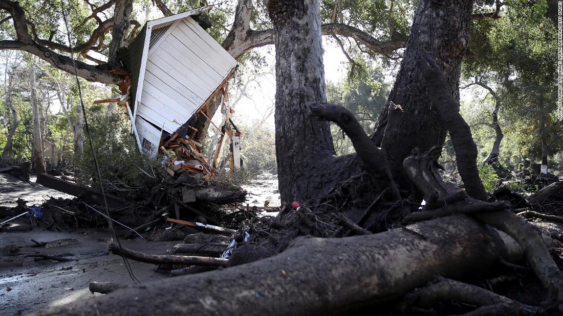
MONTECITO, CA – JANUARY 10: Part of structure sits in a tree after being knocked off its foundation by a mudslide on January 10, 2018 in Montecito, California. 15 people have died and hundreds are still stranded after massive mudslides crashed through Montecito, California early Tuesday morning. (Photo by Justin Sullivan/Getty Images)
Jan 9, 2018 – Montecito, Santa Barbara County, California, U.S. – KERRY MANN navigates the large boulders and mudflow that destroyed the home of her friend in Montecito. The woman who lives in the home has not been seen since the early hours of Tuesday. At least 15 people died and thousands fled their homes in Southern California as a powerful rainstorm triggered flash floods and mudslides on slopes where a series of intense wildfires had burned off protective vegetation last month. (Newscom TagID: zumaamericasnineteen760940.jpg) [Photo via Newscom]
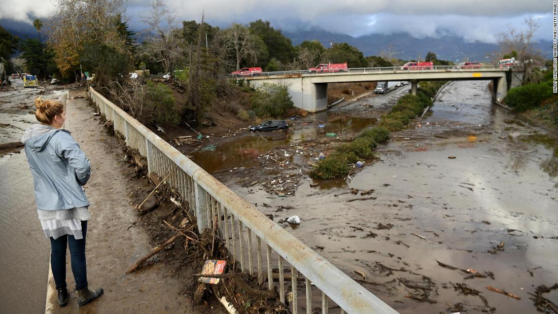
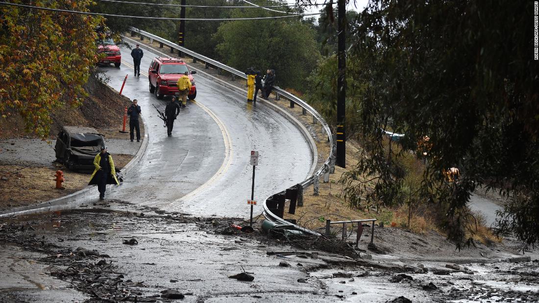
MONTECITO, CA – JANUARY 9: A view of the 101 freeway from Olive Mill Road in Montecito after a major storm hit the burn area January 9, 2018 in Montecito, California. (Photo by Wally Skalij/Los Angeles Times via Getty Images)
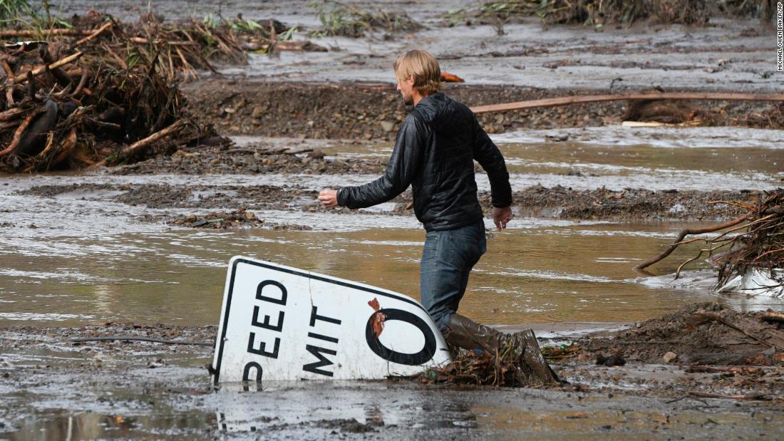
Phillip Harnsberger crosses through mud from a flooded creek on Sheffield Drive in Montecito, Calif., following heavy rain, Tuesday, Jan. 9, 2018. Multiple people were killed and homes were torn from their foundations Tuesday as downpours sent mud and boulders roaring down hills stripped of vegetation by a gigantic wildfire that raged in Southern California last month. (AP Photo/Michael Owen Baker)

Mud fills the interior of a car destroyed in a rain-driven mudslide in a neighborhood under mandatory evacuation in Burbank, California, January 9, 2018.
Mudslides unleashed by a ferocious storm demolished homes in southern California, authorities said Tuesday. Five people were reported killed. / AFP PHOTO / Robyn BeckROBYN BECK/AFP/Getty Images

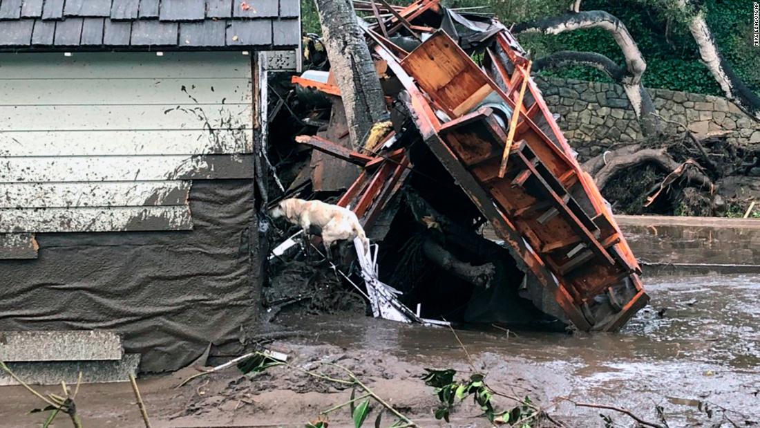
In this photo provided by Santa Barbara County Fire Department, Santa Barbara County Fire Search Dog Reilly looks for victims in damaged and destroyed homes in Montecito, Calif. following deadly runoff of mud and debris from heavy rain on Tuesday, Jan. 9, 2018. At least five people were killed and homes were swept from their foundations Tuesday as heavy rain sent mud and boulders sliding down hills stripped of vegetation by a gigantic wildfire that raged in Southern California last month. (Mike Eliason/Santa Barbara County Fire Department via AP)
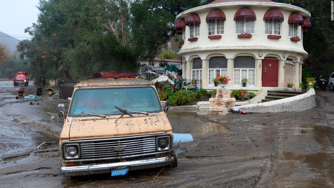
Mud flows leaves a van stuck in the mud along La Tuna Canyon road in the Sun Valley neighborhood of Los Angeles, on Tuesday, Jan. 9, 2018. Homes were swept from their foundations as heavy rain sent mud and boulders sliding down hills stripped of vegetation by Southern California’s recent wildfires. (David Crane/Los Angeles Daily News via AP)
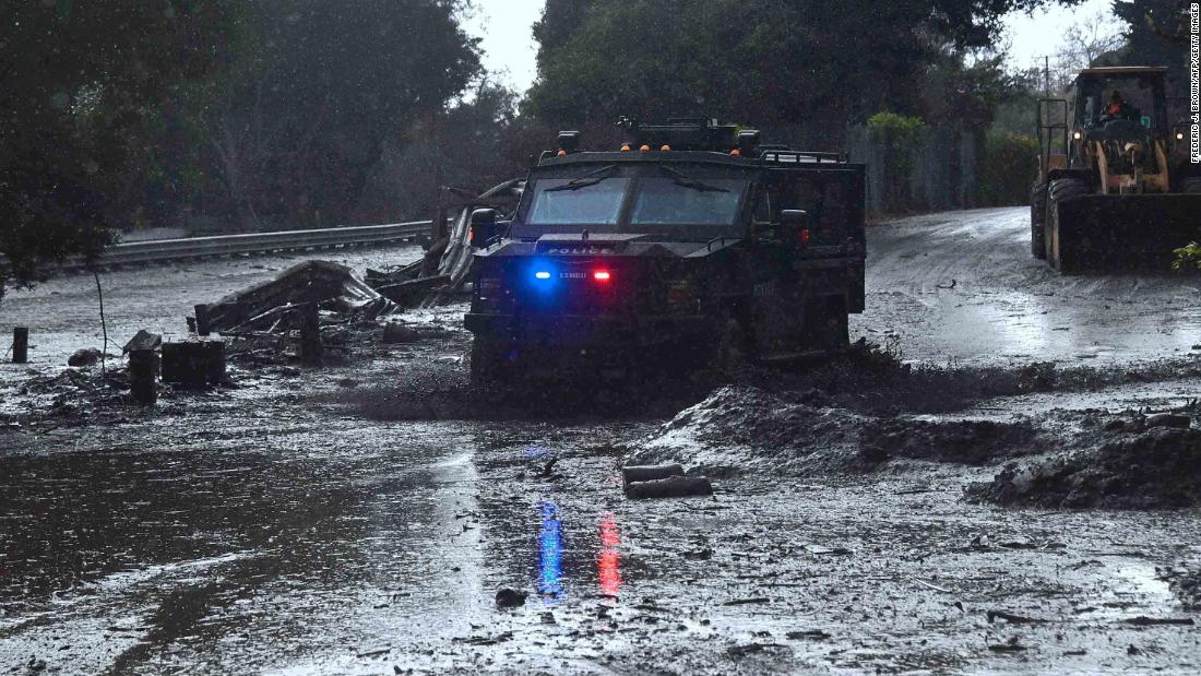
A police vehicle drives across a flooded side road off the US 101 freeway near the San Ysidro exit in Montecito, California on January 9, 2018.
Mudslides unleashed by a ferocious storm demolished homes in southern California and killed at least 13 people, police said Tuesday. / AFP PHOTO / FREDERIC J. BROWNFREDERIC J. BROWN/AFP/Getty Images
Mud runs over a road on January 9, 2018, in Burbank, California.
Mudslides unleashed by a ferocious storm demolished homes in southern California, authorities said Tuesday. Five people were reported killed. / AFP PHOTO / Robyn Beck (Photo credit should read ROBYN BECK/AFP/Getty Images)

Mud washes away personal belongings along La Tuna Canyon road in the Sun Valley neighborhood of Los Angeles on Tuesday, Jan. 9, 2018. Homes were swept from their foundations as heavy rain sent mud and boulders sliding down hills stripped of vegetation by Southern California’s recent wildfires. (David Crane/Los Angeles Daily News via AP)

Rushing rainwater fills the Los Angeles river near downtown Los Angeles on Tuesday, Dec. 9, 2018. The first significant storm of the season walloped much of California with damaging winds and thunderstorms. (AP Photo/Richard Vogel)
Cal Fire battles 600-acre wildfire in Tuolumne County.
TUOLUMNE COUNTY, Calif. (KCRA) —
Multiple homes were evacuated as Cal Fire firefighters battle a 600-acre vegetation fire in Tuolumne County. Cal Fire officials said the fire has a “dangerous rate of spread.”
The fire has been 30 percent contained.
All mandatory evacuations have been lifted as of 7 p.m. Saturday.
The following roads are under an evacuation advisory:
+ Campbells Flat Road
+ Meadowlark Lane
+ Blackbird Lane
The following roads are closed:
+ Algerine at Wards Ferry
+ Lime Kiln at Wards Ferry
The wildfire began on the 15000 block of Jacksonville Road before 3 p.m. Saturday and was headed toward Algerine Road. Jacksonville Road at Highway 120 has reopened as of 9 p.m.
Redding Fire.
The fire, reported shortly after 6 p.m. Monday, raced up the hill around Teakwood Drive, Rosewood Drive and Peppertree Lane, threatening homes in those neighbors. Two outbuildings and fences were also destroyed, and decks and siding were damaged.
Entire neighborhoods stood outside of their homes, enduring the smokey conditions, to watch as firefighters battled the fire.
Redding resident Laura McDuffey took this photograph of the fire from her backyard. (Photo: Photo courtesy of Laura McDuffey)
A fire investigator, looking into what set the fire off, talked to witnesses. Late Monday night, fire crews continued to mop up, and Battalion chief Rob Pitt anticipated they would stay there through the morning to make sure to put out any spots.
The cause remains under investigation, though the initial reports were that some youths had been seen in the greenbelt, a Redding fire official said.
“That would not be abnormal. We have juveniles playing in the greenbelts all the time,” Battalion Chief Rob Pitt said. “Unknown if they are involved, but we do have an investigator on scene.”
Firefighters said Tuesday morning an Arbuckle Court resident heard around 6 p.m. what sounded like a girl screaming from the open space behind his home.
When that resident looked over a fence, he saw the fire burning in the dry grass and two juveniles running from the area, firefighters said.
One of them was described as a boy, about 15 to 18 years old and 5 feet 9 inches tall with blonde hair. He was wearing a turquoise tank top and gray shorts.
The other was a girl about 15 or 16 with brown hair and wearing a pink shirt.
Those with any information about their identities are asked to call 225-4141.
The fast-moving fire gave residents in the area a scare.
Bonnie Boyce, who lives at the corner of Teakwood and Rosewood, said she opened her sliding patio door so her dog, Buddy, could go outside. She smelled smoke, so she went to her front door to investigate.
When she opened the door, she saw the tall flames behind a home and police cars and fire engines rushing down Teakwood.
“I’ve got a bag packed,” she said, holding on to a cool, wet towel around her neck and glass of water in her other hand.
Over the years, firefighters have been called to numerous fires at the same canyon, Pitt said.
When firefighters arrived, it had grown to two acres and was being fanned by a south wind and extreme low humidity of 5 percent to 7 percent.
It pushed the incident from a second-alarm fire, which prompts all eight city engines and available resources to respond, to a third-alarm fire. A third alarm brings out five additional engines from Shasta County fire and the California Department of Forestry and Fire Protection, aircraft and hand crews.
Laura McDuffey, who lives two doors from the house that sustained significant damage, said she went to her neighbors’ homes to alert them about the fire. She and family members grabbed garden hoses in hopes of keeping the fire back.
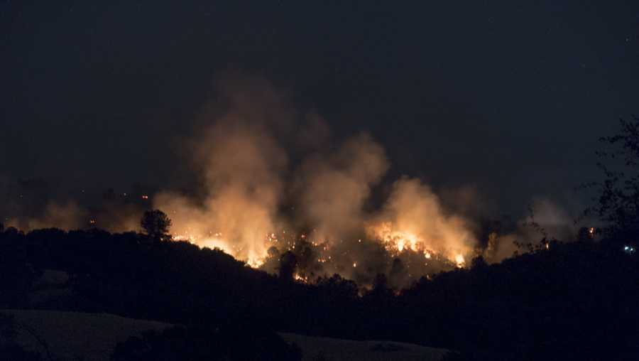
Wildfire burning near Big Bear Lake grows to 950 acres amid sweltering California heat wave.
A wildfire in the San Bernardino Mountains continued to grow overnight as warm temperatures and low humidity helped push flames over a ridge top and deeper into rugged terrain, authorities said Tuesday. “Compared to fire behavior during the day, the fire did lay down a bit. But the fire did remain active,” said U.S. Forest Service Battalion Chief Chon Bribiescas. The flames chewed through dry chaparral and timber as it moved closer to Highway 18, which is closed between Baldwin Lake and Mitsubishi Plant roads, Bribiescas said. The fire was 950 acres and 10% contained Tuesday morning, officials said. An estimated 450 firefighters are battling the flames. The blaze, dubbed the Holcomb fire, began about 3 p.m. Monday near Holcomb Valley Road and North Shore Drive, the Big Bear Fire Department said. In what was the hottest day of the year so far in the mountains, two firefighters suffered heat-related injuries as the blaze spread across an estimated 850 acres in its first few hours, officials said. Temperatures reached 89 degrees in the mountain area on Monday, and were forecast to be just under that on Tuesday. “Having no cloud cover, high temperatures and those relative low humidities, it’s going to burn pretty good,” National Weather Service meteorologist Jimmy Taeger said. Conditions are expected to improve slightly in the coming days as the heat wave subsides, he said. The flames generated large plumes of smoke that were visible across the region. The smoke and wind prompted the South Coast Air Quality Management District to issue a smoke advisory, warning of unhealthy air in the eastern San Bernardino Mountains. The wildfire was not posing a threat to homes, but the San Bernardino County Sheriff’s Department said the Tanglewood Campground, the Doble Trail campground, the Baldwin Lake area and a nearby waste dump were closed as a precaution.
The blaze, dubbed the Holcomb fire, began about 3 p.m. Monday near Holcomb Valley Road and North Shore Drive, the Big Bear Fire Department said. In what was the hottest day of the year so far in the mountains, two firefighters suffered heat-related injuries as the blaze spread across an estimated 850 acres in its first few hours, officials said. Temperatures reached 89 degrees in the mountain area on Monday, and were forecast to be just under that on Tuesday. “Having no cloud cover, high temperatures and those relative low humidities, it’s going to burn pretty good,” National Weather Service meteorologist Jimmy Taeger said. Conditions are expected to improve slightly in the coming days as the heat wave subsides, he said. The flames generated large plumes of smoke that were visible across the region. The smoke and wind prompted the South Coast Air Quality Management District to issue a smoke advisory, warning of unhealthy air in the eastern San Bernardino Mountains. The wildfire was not posing a threat to homes, but the San Bernardino County Sheriff’s Department said the Tanglewood Campground, the Doble Trail campground, the Baldwin Lake area and a nearby waste dump were closed as a precaution.
Long Beach has a HEART.
The Homelessness Education and Response Team (HEART Unit) went into service on November 15, 2016. Staffed with two Firefighter/Paramedics, the HEART Unit works throughout the city connecting individuals experiencing homelessness with resources provided by the City of Long Beach Homeless Outreach Network. The HEART unit may assist units on scene of emergency responses to free up fire resources, thereby decreasing response times and improving service to the community.
1 KILLED, 6 INJURED IN LONG BEACH APARTMENT FIRE
One person was killed and six others were injured during an apartment fire in Long Beach on New Year’s Day, according to officials.
The Long Beach Fire Department said the blaze happened in the 5500 block of Dairy Avenue before 7:30 p.m.
When crews arrived to the two-story apartment complex they found fire and heavy smoke billowing from the first floor.
Firefighters were able to knock the fire down at about 7:40 p.m. A body was discovered in a first-floor unit where the fire was believed to have originated.
During the blaze, officials said a family of five living in the unit above the apartment where the fire sparked had to flee to safety.
A 28-year-old man who jumped from the second floor balcony was taken to the hospital, according to the fire department. Officials didn’t disclose the extent of his injuries.
The fire department said a 26-year-old woman, two boys, ages 9 and 7, and a 4-year-old girl were treated and released at the scene.
A 24-year-old woman who cut her leg on glass was also treated and released at the scene.
Officials said out of six apartment units, two sustained damage. The blaze remained under investigation.
Death Toll in Oakland Warehouse Fire Rises to 36 as Search Continues
Nikki Kelber and Carmen Brito describe seeing entire walls and a hallway engulfed in flames before escaping from the burning warehouse.
By ELSA BUTLER and THOMAS FULLER on Publish DateDecember 5, 2016. Photo by Jim Wilson/The New York Times. Watch in Times Video »
OAKLAND, Calif. — Carmen Brito was asleep on Friday night when she suddenly woke up gasping for breath. Outside her small studio, one floor down from where a raging concert was taking place, she saw her neighbor’s wall on fire.
“I’m pretty sure I was the first person to see the fire, and when I saw it, it was bigger than I was,” said Ms. Brito, 28. The inferno killed at least 36 people and is regarded as one of the worst structure fires in the United States in over a decade.
On Sunday, firefighters were digging through the ruins of the warehouse, where people had gathered for an electronic dance show on Friday when flames ripped through the building, collapsing the floors. The search of the building, which had only two exits, could continue for days, officials said at a news conference, warning that the death toll could climb considerably higher.
The authorities said on Monday that 11 victims have been positively identified. One victim was the son of a local law enforcement officer, said Sgt. Ray Kelly of the Alameda County sheriff’s office. “This tragedy has hit very close to home for our agency,” he said. Other victims were from countries in Europe and Asia. The officials were in the process of contacting agencies abroad.
More than 35 people were killed on Friday night in a warehouse fire in Oakland, Calif. The authorities expect the death toll to rise.
Ms. Brito was just one member of a community of roughly 25 artists who inhabited the building illegally — but in plain sight of Oakland city officials. The building, which was known as the Ghost Ship and has been under investigation for code violations, had a permit to function as a warehouse, but not as a residence or for a party. A criminal investigation began on Sunday.
Ms. Brito said the fire started at the very back of the building, in a studio next to hers, when the couple who occupied the room were gone. She said a firefighter investigating the blaze had asked her whether the couple had recently installed a refrigerator, which they had, raising the possibility that the building’s electrical system played a role. The officials said on Monday that they believed they had identified the section of the building where the fire started, but cautioned that they were no closer to finding a cause.
Ms. Brito and another survivor, Nikki Kelber, 44, said the building’s renters had repeatedly asked its owner to upgrade the electrical system, which failed often enough that residents had flashlights in their studios.
Ms. Kelber and Ms. Brito said that the building had many fire extinguishers and that one of the residents, Max Ohr, tried to use one on the flames but soon gave up.
“It was like trying to put out a bonfire with a squirt gun,” Ms. Brito said.
The residents of the building said they had been priced out of parts of the San Francisco Bay Area that have become increasingly unaffordable. They called themselves refugees and were happy to be living among a community of like-minded artists paying an affordable rent.

Oakland itself has seen rents and home prices skyrocket with the technology boom. The high cost of living has led to alternative housing arrangements across the region, from a community of homes made of shipping containers to lines of recreational vehicles on Silicon Valley side streets.
But these spaces, while often illegal, are subject to the same market forces rippling through the broader market. That has given outsize power to the so-called master tenants who control the lease of a building and, at least in some cases, can make money by subletting to struggling artists willing to live in substandard conditions.
The Ghost Ship was one of these illegal living spaces. Residents and visitors described it as both a haven for artists and a fire trap, with a warren of trailers, broken pianos and stacks of wood and a complex network of electrical cords and generators.
It was home for jewelers, metalworkers, dancers, musicians and others, and parties that brought hundreds to its labyrinthine corridors. But it was also plagued by discord and the whims of its two master tenants, Derick Ion Almena and Micah Allison, who lived there with their three children, ages 13, 7 and 6.
Several residents said they were lured in by the promise of cheap rent and a creative community, only to find that their new home had no heat, sporadic electricity and a master tenant — Mr. Almena — who would bring in homeless people to harass residents who crossed him. Mr. Almena was serving a sentence of three years’ probation, having pleaded no contest in January to a felony charge of receiving stolen property. Mr. Almena and Ms. Allison could not be reached for comment on Sunday.
“A lot of people were his friend because they believed in the miracle,” said Shelley Mack, 58, who moved into the space in October 2014, paying $700 to live in a mobile home inside the warehouse. “But it was a sick place.”
Ms. Mack left after several frightening episodes, she said. In one, she said, a friend of Mr. Almena’s pulled a gun on several residents.
In March 2015, the Alameda County Social Services Agency removed Mr. Almena and Ms. Allison’s children from their custody after relatives expressed concerns about safety. The agency returned the children this past June.
People familiar with the space questioned why the police did not do anything to shut down the Ghost Ship.
“That place was a tinderbox,” said Danielle Boudreaux, 40, who had visited the warehouse. “Anybody who went in there who had any kind of authority should have not allowed it to continue.”

Mr. Ohr, who took on a supervisory role among tenants, said they told the landlord that the electrical system needed upgrading. “We reached out on multiple occasions, complaining that the power wasn’t working,” Mr. Ohr said. “They made no attempt to make it right.”
The area where the fire had started had been closed off to the partygoers and was “unmonitored,” Mr. Ohr said. “There are plenty of signs that point to it being an electrical fire.”
Ms. Kelber’s studio was near one of the building’s exits, and when she spotted a “ball of fire” coming down the hallway she had only seconds to react. “After 15 seconds, the power went out, and another 30 seconds later it was completely engulfed. It went so fast.”
Ms. Kelber and Ms. Brito described confusion in the seconds after the fire was discovered because the urgent and panicked cries of residents were drowned out by a D.J.’s music in the building’s mezzanine, where the concert was underway.
The wooden statues, exposed beams and countless other objects made of timber on the ground floor of the building helped fuel a fire that raged for hours and gutted the entire structure.
Oakland Warehouse Was Used Illegally for Performances and Residences
The fire that killed more than 30 people on Friday in Oakland occurred in a warehouse that was being used as an artistic and performance venue.
The building, known as the Ghost Ship, also housed a community of roughly 25 artists who lived in the building even though it should not have had residents.

Carmen Brito, who lived in an apartment at the back of the first floor, said she thought the fire started in a studio next to hers.
The warehouse had two floors and two entrances, and it was filled with vintage furniture, rugs and other objects, as well as musical instruments.
Besides the front entrance on 31st Avenue, there was a side entrance that had been cut into the south wall that opened onto a vacant lot. There was also an opening in the north wall on the second floor that provided access to a bathroom in the adjacent building, according to Omar Vega, the owner of Custom O’s, an automotive shop on the first floor.

Inside the front entrance was a stairway that had been added to the original warehouse space, Mr. Vega said. The stairway wound to the left up to the second floor, where a performance of electronic music had drawn several dozen people on Friday night.
The authorities said the evacuation of the building may have been complicated by those stairs, which were at least partly constructed of pallet wood.

Residents and visitors described the building as both a haven for artists and a fire trap, with a warren of trailers, broken pianos and stacks of wood and a complex network of electrical cords and generators.
Aug 10, 2016
Fire crews gained some significant ground on a massive Northern California wildfire that has destroyed 175 homes, businesses and other structures and charred nearly 7 square miles.
California Department of Forestry and Fire Protection spokesman Daniel Berlant says the fire in Lower Lake, about a two hour drive from San Francisco, was 20 percent Monday.
The progress came as authorities arrested 40-year-old Damin Anthony Pashilk of Clearlake, California, on 17 counts of arson Monday. Pashilk is suspected of sparking the blaze that exploded over the weekend. Officials say he is also suspected in several other fires over the past year in Lake County.
Roughly 1,600 firefighters are battling the blaze Tuesday through warm temperatures and light winds.

(Steven Brittain, for Victor Valley News)
Pilot Fire Now 64% Contained; “Significant Progress” Made Overnight
HESPERIA, Calif:(VVNG.com)- Firefighters made significant progress over the last 24 hours and the Pilot Fire is now at 64% containment and 7,861 acres.
A total of 1,746 personnel are assigned to the Pilot Fire including, 105 engines, 14 water tenders, 12 helicopters, 1 air tanker, 46 hand crews, and 18 dozerz.
Today’s temperature is expected to be warmer with a high near 90 degrees, humidity is expected to remain in the low teens. Winds will continue out of the south-west from 10-15 mph with gust as high as 30 mph.
Inmate Fire Crews were deployed to the Pilot Fire on August 7th & 8th with a 20 man team. On August 9th & 10th a 10 man team responded to the fire. The Inmate Fire Crews have worked tirelessly alongside firefighters digging trenches and clearing brush.

Inmate Crews (photo courtesy of SBSD Headquaters)
Aug 9, 2016

(Steven Brittain, for Victor Valley News)
Aug 9, 2016
HESPERIA, Calif: (VVNG.com)- On the morning of Tuesday, August 9th the San Bernardino County Board of Supervisors declared a local state of emergency in response to the Pilot Fire.
“The purpose of this is to make County Government eligible for state and perhaps eventually federal reimbursement for any of the costs of fighting the fire,” stated County spokesman David Wert.
“It might also make those who suffered a loss from the fire eligible for state and perhaps eventually federal assistance.”
As of 3:00 p.m. the Pilot Fire continues to burn in the San Bernardino National Forest’s and has charred6,963 acres and is only 6% contained.

(Steven Brittain, for Victor Valley News)
Southern California fire grows to nearly 6K acres as crews fight for containment.
By Andrew V. Pestano, Doug G. Ware and Shawn Price
Aug. 9, 2016

Firefighters battle the Pilot Wildfire in San Bernardino County, Calif., on Monday, which is one of several fires burning across the state. Officials said Monday that the cause of the fire is unknown and no injuries have been reported. Photo courtesy San Bernardino Fire Department
SAN BERNARDINO , Calif., Aug. 8 (UPI) — An aggressive wildfire in Southern California has quickly scorched more than 6,300 acres and has prompted authorities to order mandatory and voluntary evacuations of thousands of homes, fire officials said Monday.
The evacuations were ordered for the Summit Valley area in San Bernardino County — about 75 miles northeast of downtown Los Angeles. The blaze, called the Pilot Fire, has so far burned more than 6,300 acres with only 6 percent containment, officials said Monday.
The fire began about noon Sunday east of Highway 138 and Silverwood Lake, and smoke advisories were issued for the Mojave Desert area. Officials said 840 firefighters with bulldozers, helicopters and tankers has been deployed to combat the flames.

Firefighters gather to execute a strategy to fight the Pilot Wildfire in San Bernardino County, Calif., on Monday. The fire started Sunday afternoon and had destroyed nearly 5,000 acres by Monday afternoon, authorities said. Photo courtesy San Bernardino National Forest
Despite the fire’s large size and expanding danger, no injuries and no structural damage has so far been reported.
“Because of the aggressive attack by our firefighters, we were able to protect homes,” said Bob Poole, U.S. Forest Service spokesman. “These guys — they’re highly trained, they’re highly motivated and they’re doing an incredible job in difficult conditions.”
There have been, however, a few close calls. Officials said Monday that firefighters worked through the night to keep one home away from the flames near Highway 173, the San Bernardino Sun reported.
The National Wildfire Coordinating Group warned residents to avoid using hobby drones, as they “pose a major safety threat to firefighting pilots and firefighters.”
“When a hobby drone is flown into a fire area, incident commanders have no choice but to suspend air operations and ground aircraft until the drone is removed from the area,” the NWCG said in a statement. “A collision could easily result in major damage to our aircraft, injuries to the pilot and crew on board as well as firefighters below, and worse, a midair collision.”
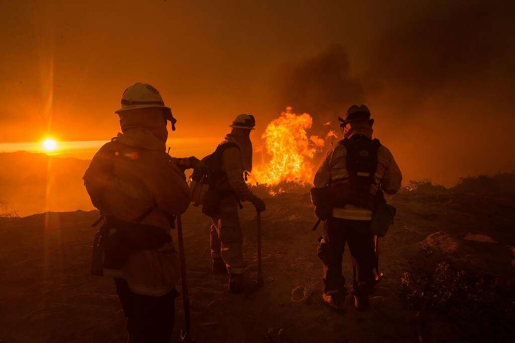
Deadly Soberanes fire north of Big Sur grows; Southland’s Sand fire closer to being contained.
July 29,2016 8:50 AM
The Soberanes fire burns in Palo Colorado Canyon in the Big Sur region on Monday. (David Royal / Monterey County Herald via Associated Press)
Story By Brittny Mejia and Veronica Rocha
Firefighters made gains on Southern California’s deadly Sand fire, the struggle continued Friday with containment of a massive wildfire burning north of Big Sur that has scorched more than 30,000 acres.
The Soberanes fire, which has burned out of control for days and claimed one life, is only 15% contained, according to the California Department of Forestry and Fire Protection. To date, 31,386 acres have burned, fire officials said.
A total of 41 homes and 10 outbuildings have been destroyed by the blaze, which started a week ago in Soberanes Creek. The fire is threatening 2,000 structures and has forced hundreds of residents to evacuate, fire officials said.
The unpredictable blaze also claimed the life of Robert Reagan III, a bulldozer operator called in Tuesday to help battle the fire. At some point, he suffered fatal injuries in a remote area on the southeast end of the fire in Garrapata State Park in Carmel.
Fire crews have faced difficulties getting into the area where the fire is burning, said Cal Fire Capt. Raymond Martinez.
“The Monterey area where the fire is burning is very steep, rocky terrain which is hampering our containment effort,” Martinez said. “That’s the biggest challenge right now.”
Flames have also encroached on illegal marijuana growing operations and led to unexpected rescues.
On Monday, two people were tending to a marijuana grow when they became trapped by flames. They were found by Monterey County sheriff’s deputies.
All 900 marijuana plants were destroyed by the fire.
Then on Tuesday, eight men who had been lost for six days and were surrounded by flames while working on an illegal marijuana grow were rescued by firefighters, the Monterey Herald reported. Cal Fire officials said the men were not injured.
In Santa Clarita Valley, the deadly Sand fire has burned 38,873 acres and is now 85% contained. There were 1,718 firefighters working on the fire, a drop from early on when there were upwards of 3,000 firefighters.
“We’re by no means 100% contained, but we are at a point where we’re trying to match the needs of the incident with the personnel we have on the incident,” said U.S. Forest Service spokesman Justin Correll.
Firefighters are being released so they can be available for other fires, Correll said.
“We’re still keeping firefighters on this fire until 100% containment and even after,” Correll said.
The flames overtook Robert Bresnick, 67, who had been evacuating with his girlfriend and pets. He was discovered dead at about 7:20 p.m. Saturday inside a burned car in a driveway outside his girlfriend’s home in the 26700 block of Iron Canyon Road.
The deadly fires prompted acting Gov. Tom Torlakson to declare a state of emergency on Tuesday for Los Angeles and Monterey counties.
Drones force firefighters to temporarily halt air assault on wildfire
A wildfire that has scorched more than 5,200 acres in the San Gabriel Mountains above Duarte and Azusa was 62% contained as of early Sunday morning, according to the U.S. Forest Service.The San Gabriel Complex fire is actually two fires that started on Monday — the Reservoir fire and the Fish fire — that forced hundreds of residents to evacuate over the last week as high temperatures baked Southern California.
By Saturday, firefighters appeared to be gaining the upper hand. Evacuation orders were lifted and an American Red Cross evacuation center was closed. The forest service also reopened the Chantry Flats Recreation Area. Fire officials complained, however, that several drones had been spotted over the fire this weekend, forcing them to temporarily halt air operations. Some firefighters have been airlifted by helicopter to remote stretches of the fire.
2 FIRES CHAR 4,400 ACRES WITH NO CONTAINMENT IN ANGELES NATIONAL FOREST ABOVE AZUSA, DUARTE
By Leo Stallworth and ABC7.com staff
Fire boats respond to a fire on the Seal Beach Pier on May 20, 2016. (Credit: KTLA)
The old Ruby’s Diner building at the end of the Seal Beach Pier was gutted by a spectacular fire that sent smoke towering over the coastline Friday morning.

Fire boats respond to a fire on the Seal Beach Pier on May 20, 2016. (Credit: KTLA)
The fire was first reported about 7:45 a.m., Orange County Fire Authority Capt. Larry Kurtz said.
The building that burned was once home to a Ruby’s Diner, which closed in 2013. Smoke was still coming out of the gutted structure more than 7 hours after the fire broke out, and firefighter expected it would be smoking for hours to come.
Aerial video from Sky5 showed three boats initially surrounding the old restaurant, using water cannons to douse the flames.
“A fire on a building at the end of a pier is definitely a challenge,” Kurtz said.
Firefighters ran hose for hundreds of feet down the course of the pier, and boats from the Long Beach Fire Department were helping, he said. Dozens of fire engines could also be seen parked near the pier.

Viewer Michael Sosa sent this photo to KTLA of a fire burning at the end of the Seal Beach Pier on May 20, 2016.
Crews tried to keep the flames from burning too much of the actual pier, Kurtz said.
A fourth boat, described as the largest fire boat on the West Coast in a tweet by the Long Beach Fire Department, later joined the fight and put two more large streams of water onto the flames.
The intense streams of water coming from the Long Beach boat was so strong it stripped roofing off the burning building, video showed.
The roof appeared to have collapsed once the flames were largely extinguished. It was not clear how much damaged was done to the pier itself.
Kurtz said he did not know when fire inspectors had last visited the building.

Fire boats respond to a fire on the Seal Beach Pier on May 20, 2016. (Credit: KTLA)
The restaurant’s closure prompted a fence to be erected to keep people from going into the abandoned structure, Seal Beach Police Department Lt. Michael Henderson said.
The fence has been a sore spot in the community, where some have called for the business to be torn down so access to the end of the pier could be restored.
Friday’s fire was not the first incident to leave the pier in need of repair.
A storm in 1983 tore more than a thousand feet of deck off the pier’s pilings, the Los Angeles Times reported.

In a Feb. 11, 1983, Times file photo, a surfer rides a wave through a missing section of the Seal Beach Pier that was washed out by a Jan. 27 storm. (Credit: Cliff Otto/Los Angeles Times)
It was damaged again when fires struck in 1992 and 1994, according to the Times.
And just last year, powerful winds and surf from Hurricane Marie caused some structural damage, the Orange County Register reported.
The cause of Friday’s fire was under investigation and firefighters continued to overhaul the scene in the afternoon hours.
Investigators from the federal Bureau of Alcohol, Tobacco, Firearms and Explosives were aiding in the case, Kurtz said.
“We’re going to be here for probably a few more hours. It’s dirty work; it’s very long work. But we are going to find out what caused this fire,” Kurtz said.
The pier will likely remain closed until the fire’s cause has been determined.